Bible Map
 The Bible refers to geographical locations in every book. To better understand the Bible, it often helps to see where these locations are and how they relate to one another. To aid in your study of the Scriptures, we've included a map application that shows an approximation
  of all the locations mentioned in the Bible. In many cases, once you've located the biblical site on the map, you can switch the view to satellite and see some of the ancient ruins. Have questions about how to use the map? Just click the Question Mark.
{mosmap kml='/dbmfiles/kmls/all.kml'|overview='1'|controltype='user'|width='100%'|height='600px'|zoomwheel='1'|align='left'|labelcolor='ffff00'|kmlsidebar='left'|kmlsbwidth='250'|kmlrenderer='geoxml'|mapprint='none'|kmlfoldersopen='0'|kmlhide='1'|maptype='terrain'|styledmap='[ { "stylers": [ { "visibility": "on" }, { "saturation": 14 }, { "lightness": -5 } ] },{ "featureType": "water", "stylers": [ { "hue": "#0091ff" }, { "lightness": -47 }, { "gamma": 0.66 } ] } ]'}
Geocoding data provided by http://www.openbible.info/. KML formatting modifications were made and additional sites were added.
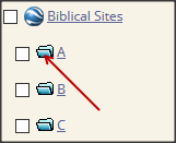 | To see the biblical sites, click on the folder icon for the letter you wish to view. You will then see the list of sites starting with that letter expand down. |
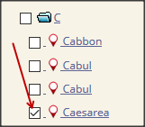 | To see where a site is on the map, simply click the square box to the left of the site name so that it's checked. A red marker will appear on the map where that location is. You may check off numerous sites at the same time and they all will appear on the map. |
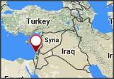 | If you click on the marker, you will see a pop-up which contains the name of the site and the Scripture reference(s) for that site. You can click on the Scripture reference to see the actual Scripture on biblegateway.com. Click the X in the upper right corner to close the pop-up. |
By holding your mouse cursor over the map and using the scroll button on your mouse, the map will zoom in or zoom out. As you zoom in you'll notice that topographical details of the land will begin to be seen as finer detail emerges.
If you would like to see current photographic detail, click the Satellite button in the upper left corner of the map. You can also navigate around the map by clicking on the map and dragging your mouse in the appropriate direction.
If you'd like to investigate another location, click on the folder icon for the letter that is currently displayed (to hide the list of sites) and then click on a new folder icon.